Engineering Division

The Engineering Division performs the engineering and design for all phases of Civil Works projects and for Military Construction and Work for Others projects as requested.

Dam & Levee Safety

Dam Safety

The U.S. Army Corps of Engineers’ (USACE) Dam Safety Program uses a risk-informed approach to manage its portfolio of 694 dams, with public safety the number one priority. This robust risk-informed approach is a best practice adopted to develop balanced and informed assessments of the safety of our dams and to evaluate, prioritize and justify dam safety decisions.

Critical to an effective safety program is, of course, the focus on public safety, but it also requires continuous and periodic project inspections and evaluations.  The Dam Safety Program seeks to ensure that USACE owned and operated dams do not present unacceptable risks to people, property, or the environment, with the emphasis on people. 
 

Levee Safety

Levees are a vital part of modern flood risk management. Many of our towns and cities would be uninhabitable without them. Levees are part of flood defense systems that may also include flood walls, pumping stations, gates closures, and other associated structures. These elements work together to reduce risk to human life and reduce economic damages from flood events. In many instances levees have been built over decades, or sometimes centuries by locals using whatever means and materials were available at the time. Records of these events are generally sparse and this has resulted in a lack of information about levee construction and performance. These unknowns add to the risk associated with a levee failing to keep the floodwaters contained in the channel or floodway as expected.

Coastal and riverine flooding continues to produce devastating consequences, in both life and economic losses, around the world. Flood and storm events around the world continue to lead to critical flood defense failures resulting in tragic losses of life and the devastation of large areas. However, despite their critical importance in mitigating flood risk, interest and investment in levees has tended to be lower than in other critical water retaining infrastructure such as dams.

Four Essential Levee Facts
  1. Flooding will happen. All rivers, streams and lakes will flood eventually. This means that all levees will be called upon to combat floodwaters at some point. 
  2. No levee is flood-proof. Levees reduce the risk of flooding, but no levee system can eliminate all flood risk. A levee is generally designed to control a certain amount of floodwater. If a larger flood occurs, floodwaters will flow over the levee. Flooding can also damage levees, allowing floodwaters to flow through an opening or breach. 
  3. Risks associated with flooding vary. If you live behind a levee, you are responsible for knowing the threat you face from flooding. Don't assume someone else is watching out for you. Take responsibility.
  4. Actions taken now will save lives and property. There are many steps you can take, from purchasing flood insurance to developing an evacuation plan, to flood-proofing your home to reporting any problems that you see. The sooner you act, the better off you'll be when the next flood occurs. Be prepared.
Collapse All Expand All
Expand List item 16257Collapse List item 16257  Introduction to levee safety

Introduction to Levee Safety

The Seattle District Levee portfolio consists of 320 levee segments within 17 flood basins spanning across Washington, Idaho, and Montana. A map showing the number of levees within each flood basin is shown below with a comprehensive list of the USACE levee portfolio available on the National Levee Database.  

           Map

The Corps of Engineers Levee Safety Program’s goal is to minimize and avoid loss of life and property damage and emphasizes the role of levees in flood damage reduction. The objective is to identify and provide awareness of levee systems that pose an unacceptable risk, to take appropriate measures to reduce risk, and to track status of levee safety programmatic activities.

The USACE Levee Safety Program applies to all completed flood damage reduction systems, including levees, channels, and floodwalls that:

  1. USACE operates and maintains;
  2. Are federally authorized projects in the Inspection of Completed Works (ICW) Program;
  3. Are non-Federal projects in the Rehabilitation and Inspection Program (RIP).

To date, there is no single federal agency responsible for levee oversight nationwide. In 2006, the United States Army Corps of Engineers (USACE) created its Levee Safety Program with the mission to assess the integrity and viability of levees and recommend courses of action to ensure that levee systems do not present unacceptable risks to the public, property, and environment.

Levee safety and effectively communicating risk is a shared responsibility among federal, state and private partners and provides the opportunity for individuals to make well informed public safety decisions for them and take appropriate action.

USACE roles and responsibilities with levee systems vary depending on the particular congressional authority assigned to it (e.g., Flood Control and Coastal Emergency Act (PL 84-99). Following are some of the primary roles:

  • Inspect and assess the reliability of the levees and floodwalls in the USACE portfolio. Information obtained from inspections of levees will be integrated into the USACE National Levee Database;
  • Communicate risks to life, property and the environment to local communities (usually through non-federal sponsors) including assessment of the level and nature of the risk;
  • Where significant risk to human life exists, assist communities in understanding their options for Interim Risk Reduction Measures (IRRM) to immediately lower risk of loss of life to people while a permanent solution can be found and implemented;
  • Assist local communities in flood fighting, both by providing information and direct assistance;
  • Develop and share state of the art approaches, tools and standards related to levee safety as a means to raise understanding of risks posed by levees as well as methods and tools to assess, communicate and address those risks.

            Federal and non-federal levees by bason


Expand List item 16258Collapse List item 16258  Flood risk general information

Flood Risk General Information

Flood risk is a combination of how well a levee can be expected to keep water from flooding the protected area and the consequences that would occur if the water did flow into that area. When the greatest risks to levee performance are identified, the repairs needed can be prioritized to provide the biggest benefit. Also, understanding and communicating what will happen should the levee fail is important from a land use planning perspective and emergency response planning perspective.

Why Assess Risk?

It is important to know how levees are expected to perform and what the potential consequences of non-performance would be – in other words, to place levee systems in a risk-informed context. The essential questions are:

  •      What possible loading events (flood, storm, earthquake, etc.) could occur?
  •      How will the levee perform when subjected to these events?
  •      What are the consequences of the levee doesn’t perform well – in particular, what loss of life could occur?

Putting levees in a risk context is a consistent and credible way to prioritize actions in a time of constrained resources. USACE plans to use risk assessments to prioritize life safety risks for its own levee safety activities, and also to provide a basis for communicating risk so levee sponsors and other stakeholders can make more informed decisions.

USACE quantifies flood risk associated with four scenarios:

  •     Breach prior to overtopping
  •     Overtopping with breach
  •     Malfunctions of levee system components
  •     Overtopping without breach

Risk Reduction, Now What?

When results of a levee inspection or risk assessment are released, levee sponsors, local leaders, and the public will all have one question: “Now. What?” A key priority is to ensure that people living or working in leveed areas get accurate and timely information so they can take action. 

USACE can advise decision-makers, but many challenges will be solved by the local community. The levee sponsor is responsible for operation, maintenance, repair, replacement, and rehabilitation of the levee system, and has the lead role in planning the way forward. USACE can provide advisory help, technical assistance, or cost-shared construction. Government agencies at every level, as well as the private sector and the public, also have roles to play.

Overall, USACE can support risk reduction activities not only through the Levee Safety Program, but also through the Flood Risk Management Plan, Silver Jackets Program, and authorities such as Floodplain Management Services, Planning Assistance to States, Advance Measures, and others.

Interim Risk Reduction

Interim risk Reduction Measures (IRRMs) are effective, interim actions taken to reduce flood risks while longer term solutions are planned and implemented. IRRMs are a critical part of responsible, adaptive flood risk management. Even levee systems that may not pose high risks can benefit from IRRMs.

USACE will develop and implement Interim Risk Reduction Measures Plans for levees USACE operates and maintains. For other levees, USACE can assist in an advisory role.

Long Term Risk Reduction

Levee safety is just one component of a comprehensive flood risk management approach. Beyond repair, rehabilitation or replacement of levees, local leaders will want to consider such factors as land use planning, development decisions, zoning, building codes, emergency management, and evacuation plans, flood proofing of structures, and ring levee construction.

Addressing System-Wide Deficiencies

USACE established the System-wide Improvement Framework process to provide eligible levee sponsors an extended period of time to address deficiencies such as erosion, seepage, or vegetation which more require a multi-year effort and coordination among multiple entities. The process supports prioritizing deficiencies so that the highest risk issues are addressed first. This joint approach to developing solutions ensures that local and regional resources come together to address site-specific conditions.

In addition, USACE can support levee sponsors with long-term risk reduction solutions through existing processes, including Section 408, 205, and 216 of its authorizing legislation.

What Can You Do?

If you live or work in a community with levees, there is a role for you. First, know your risk. No matter how strong of well maintained a levee is, there is always risk. Second, take action to reduce your risk. Have an evacuation plan. You should pay attention to flood watches and warnings and purchase flood insurance, whether it is required or not. And support your community’s effort to reduce the risk. 
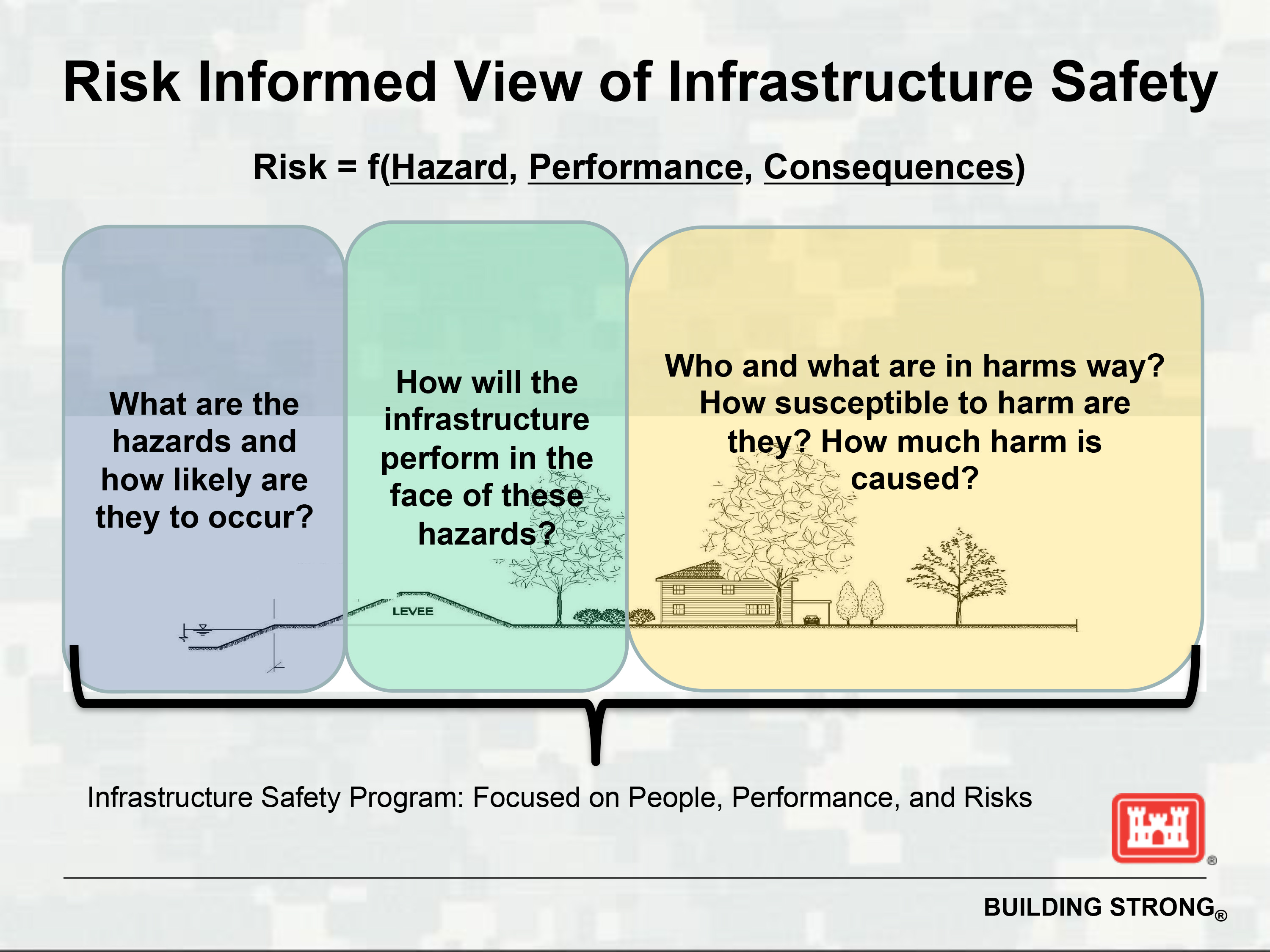
Risk-informed view of infrastructure safety

Expand List item 16259Collapse List item 16259  Technical data on levees

Many community members, sponsors, and people involved with a levee in some way often have questions like: what is a levee? How are they important? How are they designed and constructed? Why is the implementation of a levee a solution to my flood risk? While no two levees are identical they all include common parts. 


Diagram of a levee system's basic parts - Waterside
 
Diagram of a levee system's basic parts - Toe
 
Diagram of a levee system's basic parts - Embankment
 
Diagram of a levee system's basic parts - Foundation
 
Diagram of a levee system's basic parts - Crest
 
Diagram of a levee system's basic parts - Closure
 
Diagram of a levee system's basic parts - Landside
 
Diagram of a levee system's basic parts - Pump Diagram of a levee system's basic parts


Additionally, if you have questions to ask, please contact your levee sponsor, if known, or the USACE Levee Safety office of Seattle District.

There are two types of levees that are considered to be within guidance by the USACE:

  1. Federal: Designed and Constructed by the corps with an O&P manual, Project Cooperation Agreement (PCA), As-Builts, and Turn-over letter
  2. Non-Federal: Constructed by locals (land owner, dike district, city, county, etc.), may or may not have design and as-Builts, and must have a public local sponsor.

A presentation describing the levee inspection process used by Seattle District is available here. It includes the following topics:

  •       Background – Why do we do them?
  •       Types of Levees
  •       Eligibility in PL 84-99
  •       Seattle District Levee Inventory
  •       Inspection schedule- National Guidance
  •       Inspection Process
  •       Vegetation
  •       Back in the Office
  •       Report Writing and Finalization

What Kinds of Levees Are There?

Levees are constructed to a variety of heights and widths, and with a variety of materials. The height or width of a levee often depends upon possible rain and storm events. Similarly, the materials and methods used to construct a levee can vary based on their location in the U.S. and the time they were constructed.

Most levees in the U.S. are earthen embankments, meaning they are primarily made of local soil materials. However, many levees are made of or include more than one type of material. The following graphics show common types of levees and key traits of these levee types.

A Typical Levee Embankment Design:

An earthen embankment is constructed from compacted soil and is the most common type of levee in the U.S. These levees are constructed alongside a river or waterway and keep high water out of a shared area. These types of levees are used in areas with rivers or streams as well as along coasts. The materials used to build these levees can vary by location.

Diagram of levee - Earthen Embankment
Floodwall:

Like earthen embankments, floodwalls are placed alongside a body of water to help keep high water out of a shared area. Floodwalls are common in areas where there is little space to build an earthen embankment. There are several types of floodwalls, and their distinguishing feature is how they are anchored into and connected to a levee system.

Diagram of levee - Floodwall
Why it’s Important to Monitor Levees

Flood risk and levee condition are dynamic. Levees change over time: banks erode, closures rust, animals burrow, and pumps wear out. Ongoing vigilance is needed to ensure that levee infrastructure will perform properly during a flood event. USACE regularly inspects levees within its Levee Safety Program to monitor their overall condition, identify deficiencies, verify that needed maintenance is taking place, determine eligibility for federal rehabilitation assistance (in accordance with PL 84-99), and provide information about the levees on which the public relies. Inspection information also contributes to risk assessments and supports levee accreditation decisions for the National Flood Insurance Program administered by the Federal Emergency Management Agency.

Water can flow over the top of a levee:

All levees are built to a specific height and width to withstand a variety of high-water events. But a storm or rain event can bring more water than a levee is designed to handle. In these situations, water can rise high enough that it begins to flow over the top of the levee. Over time, water flowing over the top of a levee can cause it to soften, weaken, and give way. Water flowing over a levee can be dangerous, but flooding from the levee giving way often leads to swifter and deeper waters.

Diagram of levee - Levee Overtopping
Water can seep through or under the levee:

Levees are made of a variety of materials. While the goal is to have the levee be dry, or watertight, some materials are more porous and over time water may seep into, under, or through parts of a levee. Water seeping through or under a levee can cause parts of it to erode over time. This can cause portions of a levee or its foundation to sink, weaken, or break. A bubble, boil, or pooling water in the area behind the levee are signs that water is finding a path from one side of the levee to the other. Over time, this can weaken and cause a levee to break or fail.

Diagram of levee - Seepage
 
Two Types of Inspections

USACE now conducts two types of levee inspections using a Geographic Information System (GIS)/ Global Positioning System (GPS) based inspection tool that incorporates a standard levee inspection checklist. Levee sponsors are encouraged to be a part of the inspection team.

  1. Routine Inspection is a visual inspection to verify and rate levee system operation and maintenance. It is typically conducted each year for all levees in the USACE Levee Safety Program.
  2. Periodic Inspection is a comprehensive inspection conducted by a USACE multidisciplinary team that includes the levee sponsor and is lead by a profession engineer. USACE typically conducts this inspection every five years on the federally authorized levees in the USACE Levee Safety Program. Periodic Inspections include three key steps:
  • Data collection: A review of existing data on operation and maintenance, previous inspections, emergency action plans and flood fighting records.
  • Field inspection: Similar to the visual inspection for a Routine Inspection, but with additional features.
  • Final Report Development: A report including the data collected, field inspection findings, an evaluation of any changes in design criteria from the time the levee was constructed, and additional recommendations as warranted, such as areas that need further evaluation.
Additional information:
Expand List item 16261Collapse List item 16261  USACE Policy and Rehabilitation Assistance

If you are a public sponsor and have damages to your eligible levee, the following links provide information on eligibility and how to request USACE assistance following a flood event:

Expand List item 16262Collapse List item 16262  Levee inspection forms and information

Click on any of the forms below:


Expand List item 16264Collapse List item 16264  Levee Owner's Manual


Levee Owner's Manual
  • Introduction: Chapter 1
  • Maintenance of project features: Chapter 2
  • Flood preparedness: Chapter 3
  • Actions during high water events: Chapter 4
  • Additional sponsor responsibilities: Chapter 5
  • Rehabilitation and Inspection Program: Chapter 6
  • Corps inspections: Chapter 7
  • Rehabilitation assistance: Chapter 8
  • Appendix A: Acronyms and definitions
  • Appendix I: Useful links


Geospatial Services

The Seattle District Geospatial Section provides support for:

  • BIM, CIM, GIS, CAD, O&M Facility Data Exchange, COBie, ProjectWise, UAS, and Reality Capture technology support for USACE Seattle District.
  • BIM and COBie-MHS support for the USACE Mandatory Medical Center of Expertise for Defense Health Agency (DHA) and Department of Veterans Affairs (DVA)
Collapse All Expand All
Expand List item 41724Collapse List item 41724  1. General Questions
  • What are some common mistakes made with GIS submittals?
    • Not understanding that GIS submittals are required on the project.
    • Not obtaining a template from the district GIS Manager.
  • Can you convert the .rvt or .dgn or .dwg to another format? You specify a certain submittal format but the Government Furnished Materials were in another format, can you provide the submittal format required so we can update that?
    • If the Government Furnished Materials (GFM) are specified as Bentley formatted files (.dgn), and the deliverable specified as Autodesk formatted files (.dwg), it is the responsibility of the contractor to convert the files or utilize a service provider to convert the files. The Seattle District will not perform format conversions regardless of size or quantity.
    • If the GFM are Revit (.rvt) files and the deliverables specified include CAD exports, it is the responsibility of the contractor or service provider to export the sheets to CAD and ensure the files are in accordance with the CAD standards specified. The Seattle District will not perform CAD exports from BIM regardless of size or quantity.


Expand List item 41725Collapse List item 41725  2. COBie and Facility Data
Expand List item 41726Collapse List item 41726  3. Project Execution Plan (PxP)

NBIMS Process Map Templates​

  • 3.2. What are some common mistakes made with PxPs?
    • Not using the latest USACE PxP template.
    • Not including process maps for each model use (required and contractor elected) identified in "SECTION C: PROJECT GOALS / ADVANCED MODELING OBJECTIVES", "2. MODEL USES:" table.
    • Not submitting the Minimum Modeling Matrix in PDF and Excel formats.
    • Not including "C" for each contractor elective model use in "Section C: Project Goals/Advance Modeling Objectives", table "2. Model Uses".
    • Not including a point of contact in "Section D: Organizational Roles/Staffing" for each contractor elective model use.
    • Not including process maps in "Section E: Advanced Modeling Process Design" for each contractor elective model use identified.
Expand List item 41727Collapse List item 41727  4. Survey and Navigation
Expand List item 41728Collapse List item 41728  Acronynms
  • BIM - Building Information Modeling
  • CIM - Civil Information Modeling
  • CAD - Computer Aided Design
  • DHA - Defense Health Agency
  • DVA - Department of Veterans Affairs
  • GIS - Geographic Information Systems
  • M3 - Minimum Modeling Matrix
  • MBR - Minimum BIM Requirements (Defense Health Agency, Military Health System BIM requirements)
  • MHS - Military Health Systems
  • O&M - Operations and Maintenance
  • UAS - Unmanned Aircraft Systems